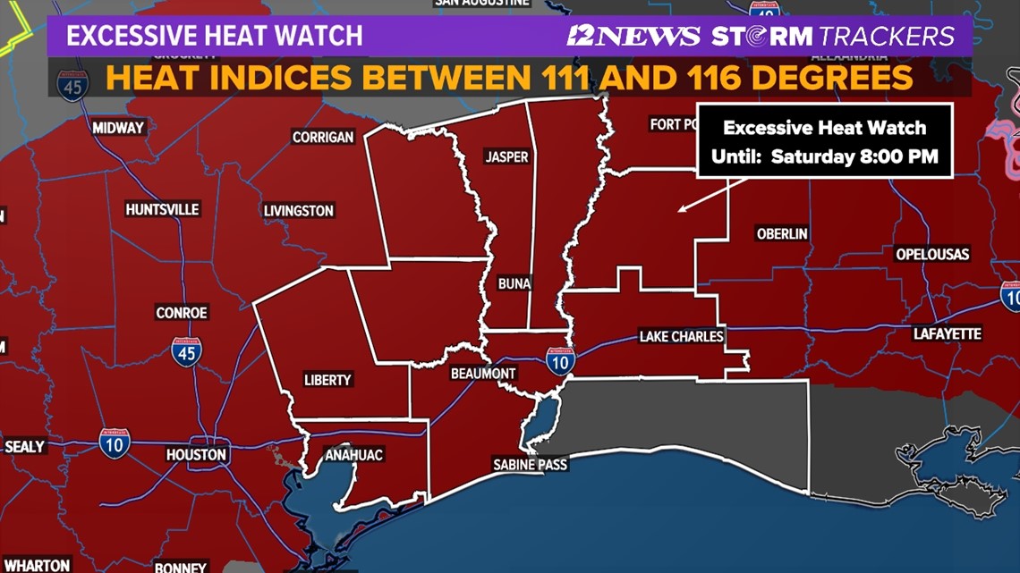
BEAUMONT, Texas — An excessive heat watch has been issued for portions of Southeast Texas starting Friday at 11 a.m.
The watch will last through Saturday 8 p.m.
An excessive heat watch means the heat and humidity are expected to increase significantly. Heat indices will range between 111 and 116 degrees. Actual highs will be in the middle to upper 90s due to upper-level high pressure.
These types of temperatures could lead to heat-related illnesses, particularly for those working or participating in any outdoor activities.


Little change is forecast Father's Day and Juneteenth in Southeast Texas.
A ridge of high pressure expanding north out of Mexico will be the main driver of our weather, which will be the heat for the foreseeable future.
Add in the relentless Texas humidity and we'll likely see heat advisories initiated later this week for heat index values, or how hot it feels in the shade to climb to values exceeding 110°.

Early-season heat waves can be dangerous since our bodies are not yet acclimated to the summer heat and are unable to efficiently mitigate its effects.
Be alert for symptoms of heat-related health issues if working outdoors this week.
Please, please, please! Do NOT leave children or pets unattended in vehicles for ANY amount of time. Car interior temperatures can become deadly quickly.
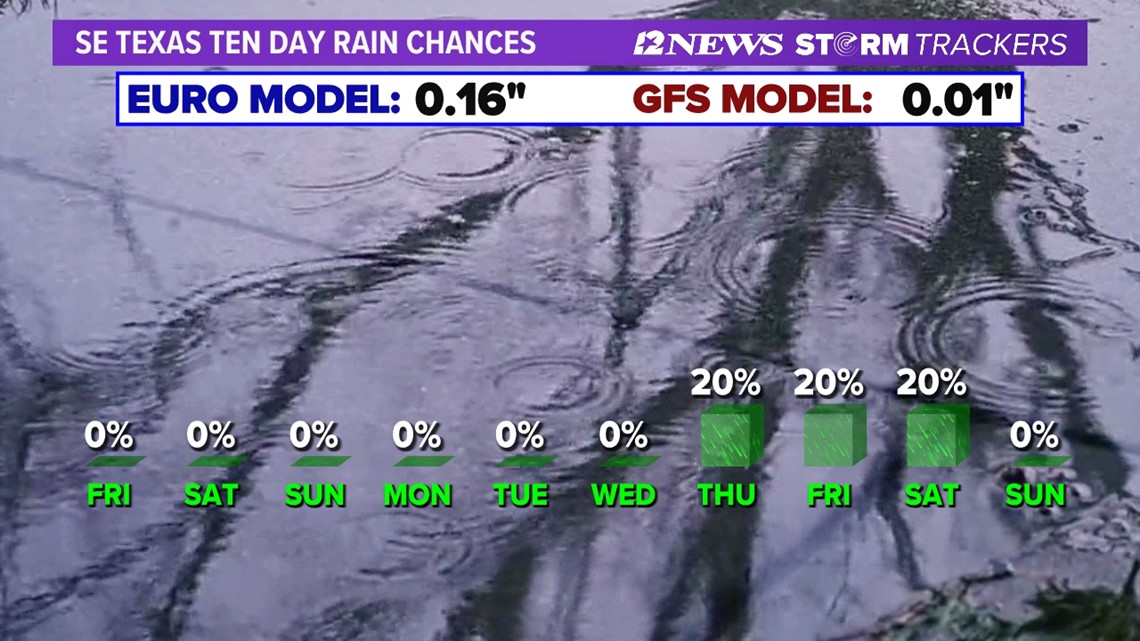
Slight chance of storms returns late next week.

Short Term Forecast
Triangle Tonight: Partly cloudy, very warm, humid and breezy. Low near: 80° in Beaumont, near: 83° in Orange and 81° in Port Arthur. Winds: South: 10-15 mph.
Lakes Area Tonight: Partly cloudy, warm, humid and breezy. Low near: 77°. Winds: South: 10-15 mph.
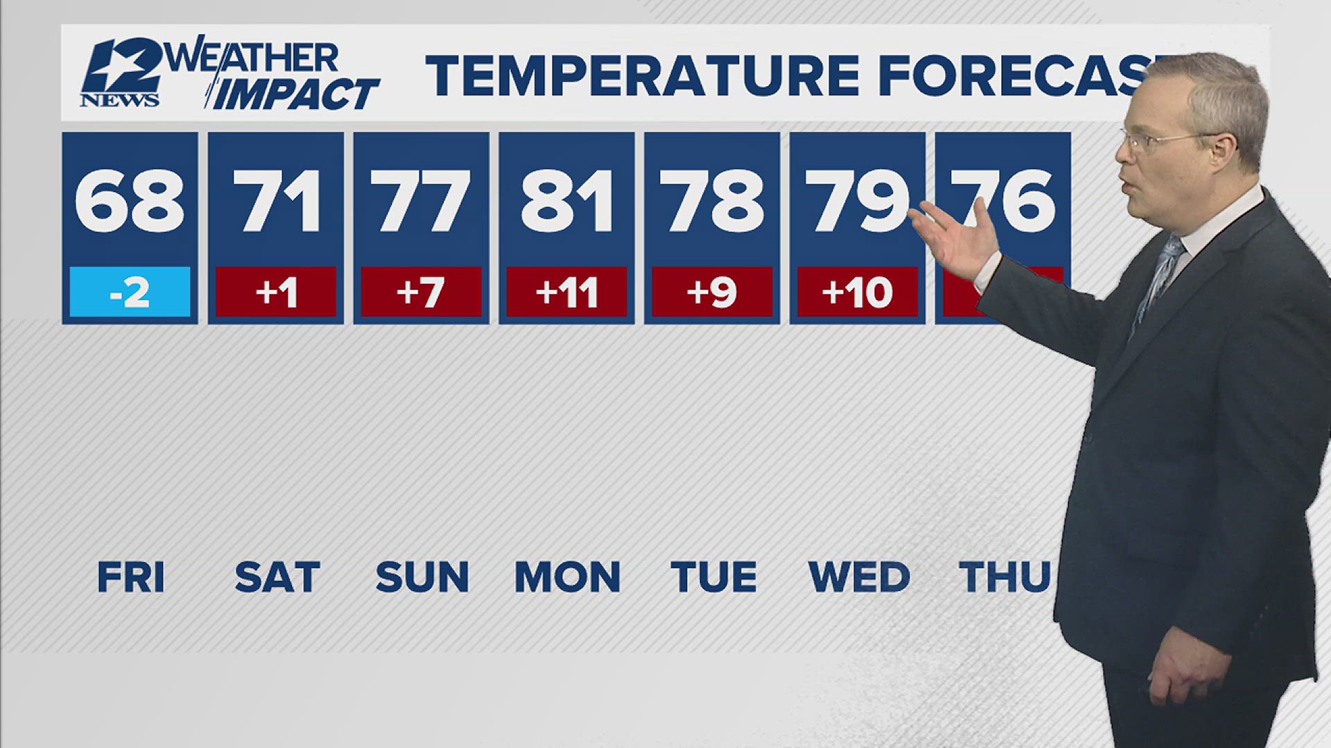
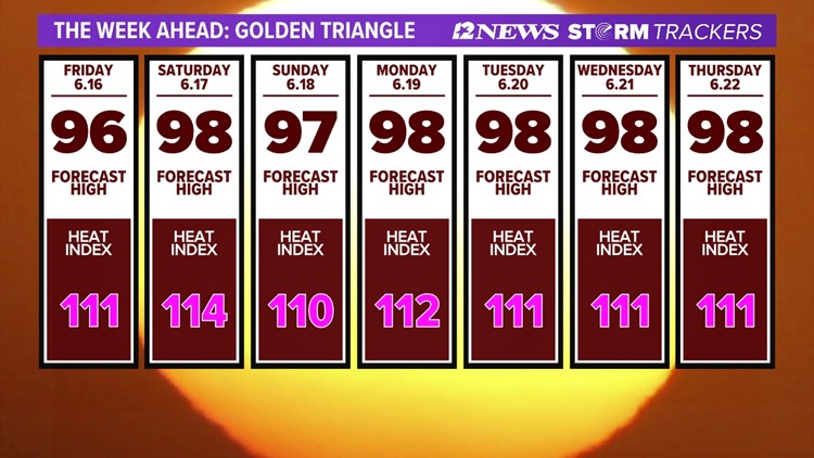
Triangle Friday: Mostly sunny, hot, humid and breezy. Excessive Heat Watch. High near: 96° in Beaumont, High near: 96° in Orange and High near: 94° in Port Arthur. Heat Index near 111°. Winds: South-Southwest: 10-15 mph with gusts to 20 mph.
Lakes Area Friday: Mostly sunny to partly cloudy, hot, humid and breezy. Excessive Heat Watch. High near: 97°. Heat Index near 116°. Winds: South-Southwest: 10-15 mph with gusts to 20 mph.
Extended Forecast
Saturday (6/17): Mostly sunny, hot, humid and breezy. Excessive Heat Watches. Low near: 79°. High near: 98°. Heat Index near 114°. Winds: South-Southwest: 5-15 mph.
Father's Day Sunday (6/18): Mostly sunny, hot, humid and breezy. Low near: 78°. High near: 97°. Heat Index near 110°. Winds: South-Southwest: 10-15 mph with gusts to 25 mph.
Monday Juneteenth (6/19): Mostly sunny, hot, humid and breezy. Low near: 80°. High near: 98°. Heat Index near 112°. Winds: South-Southwest: 10-15 mph with gusts to 20 mph.
Tuesday (6/20): Mostly sunny, hot, humid and breezy. Low near: 78°. High near: 98°. Heat Index near 111°. Winds: South-Southwest: 5-10 mph with gusts to 20 mph.
Wednesday (6/21): Mostly sunny, hot and humid. Low near: 78°. High near: 98°. Heat Index near 111°. Winds: South to Southeast: 5-15 mph.
Thursday (6/22): Partly cloudy, hot and humid. Low near: 77°. High near: 98°. Heat Index near 111°. Winds: South-Southeast: 5-15 mph.
Friday (6/23): Partly cloudy, hot and humid with a 20% coverage of showers and thunderstorms. Low near: 78°. High near: 96°. Winds: South to Southeast: 5-15 mph.
Saturday (6/24): Partly cloudy, hot, humid and breezy with a 20% coverage of showers and thunderstorms. Low near: 77°. High near: 96°. Winds: South: 5-15 mph with gusts to 20 mph.
Sunday (6/25): Partly cloudy, hot, humid and breezy with a 20% coverage of showers and thunderstorms. Low near: 77°. High near: 96°. Winds: South: 5-15 mph with gusts to 20 mph.