

BEAUMONT, Texas —
Forecast Discussion
An active pattern is forecast for SE Texas the next couple of days as disturbances will move through the area sparking numerous showers and thunderstorms. The threat for flash flooding is high especially near our rivers, creeks, and bayous that have already been swollen.
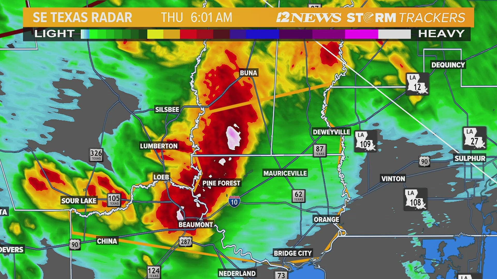
The National Weather Service has issued several warnings Thursday morning.
- A flash flood warning has been issued through 8 a.m. for much of Tyler County and northwestern Jasper County. One to four inches of rain has fallen and an additional three - five inches are possible.
- A severe thunderstorm warning has been issued for portions of Jefferson, Newton, Jasper and Orange Counties until 6:45 a.m. with the potential for 60 mph wind gusts and quarter sized hail. At about 5:45 a.m., it was just to the east of Sour Lake along HWY 105, moving east at 40 mph.
- A severe thunderstorm warning is in effect through 6 a.m. for much Hardin County with the potential for hail an inch and a half in diameter and damaging wind gusts up to 60 mph.
Over the weekend, the "storm track" will shift a bit further north which will keep higher chances of storms over the Lakes Area on the order of a 50-60% coverage with a lower 30-40% coverage for the Triangle.
A weak ridge of high pressure will then build over the Gulf Coast the middle to later part of the next week. This will push low temperatures into the middle 70s with highs at or just above 90 degrees for the first time this year.
Short Term Forecast
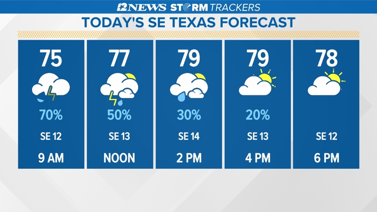
Triangle Today: 70% coverage of mainly mainly morning showers and thunderstorms followed by a warm, humid, windy afternoon with slowly decreasing cloudiness. Highs in the lower 80's. Winds: Southeast 5-15 mph with gusts to 25 mph.
Lakes Area Today: 80% coverage of mainly mainly morning showers and thunderstorms followed by a warm, humid, windy afternoon with slowly decreasing cloudiness. Highs in the upper 70's. Winds: Southeast 5-15 mph with gusts to 25 mph.
Triangle Tonight: Becoming cloudy, cool and humid with with a 70% coverage of showers and thunderstorms after 4 am. Lows in the lower 70's. Winds: Southeast 5-15 mph.
Lakes Area Tonight: Becoming cloudy, cool and humid with a 60% coverage of showers and thunderstorms after 4 am. Lows in in the lower 70's. Winds: Southeast: 5-15 mph.
Extended Forecast
Friday (5/3): 80% coverage of morning showers and thunderstorms in the Triangle and a 90% coverage in the Lakes Area followed by warm, humid, windy afternoon with decreasing cloudiness. Low near: 71°. High near 81°. Winds: Southeast 5-15 mph with gusts to 25 mph.
Saturday (5/4): Warm morning followed by a partly sunny, warm, humid, windy afternoon with a 30% coverage of showers and thunderstorms in the Triangle and a 50% coverage in the Lakes Area. Low near: 72°. High near 81°. Winds: Southeast 5-15 mph with gusts to 25 mph.
Sunday (5/5): Warm morning followed by a partly cloudy warm, humid, windy afternoon with a 40% coverage of showers and thunderstorms in the Triangle and a 60% coverage in the Lakes Area. Low near: 72°. High near: 84°. Winds: Southeast 5-15 mph with gusts to 25 mph.
Monday (5/6): Warm morning followed by a partly sunny, warm, humid windy afternoon with a 20% coverage of showers and thunderstorms. Low near: 72°. High near: 86°. Winds: Southeast 5-15 mph with gusts to 25 mph.
Tuesday (5/7): Warm morning followed by a partly sunny, warm, humid windy afternoon. Low near: 74°. High near: 86°. Winds: Southeast 5-15 mph with gusts to 25 mph.
Wednesday (5/8): Warm morning followed by a partly cloudy, warm, humid, breezy afternoon. Low near: 75°. High near: 89°. Winds: Southeast 5-15 mph with gusts to 20 mph.
Thursday (5/9): Warm morning followed by a partly sunny, warm, humid, breezy afternoon. Low near: 76°. High near: 89°. Winds: Southeast 5-15 mph with gusts to 20 mph.
Friday (5/10): Warm morning followed by a partly cloudy, warm, humid, breezy afternoon. Low near: 74°. High near:89°. Winds: Southeast 5-15 mph with gusts to 20 mph.
Saturday (5/11): Warm morning followed by a partly sunny, warm, humid, breezy afternoon. Low near 75°. High near 88°. Winds: Southeast 5-15 mph with gusts to 20 mph.