
BEAUMONT, Texas — The National Weather service has now issued a tornado warning in parts of Tyler County while the rest of Southeast Texas remains under a tornado watch.
The National Weather service announced the watch at about 1:36 p.m. CT.
We're expecting an active weather day throughout Southeast Texas with the potential for some storms that could become strong to severe.
INTERACTIVE RADAR | Follow the weather on our interactive radar
The potential for severe weather is mainly expected in the afternoon hours.
Sufficient wind speed and directional shear plus instability should be in place mainly over the Triangle thanks to a warm front and a jet streak.
An isolated tornado cannot be ruled out if a supercell develops off towards our southwest. Aside from the possibility of a tornado we can expect a windy day with gusts up to 40 mph and numerous showers and thunderstorms.
FULL FORECAST | Strong storms possible Monday in Southeast Texas
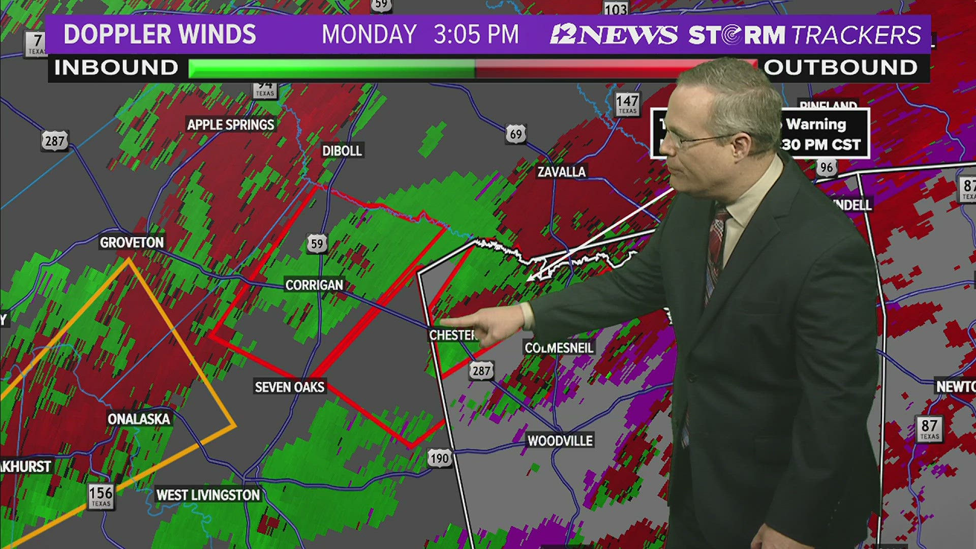
3:01 p.m.: The National Weather service has issued a tornado warning in parts of Tyler County until 3:30 p.m. in an area in the northeastern part of the county from Chester to Rockwall.
Radar indicated a tornado on the ground and quarter size hail is possible according to the weather service.
2:57 p.m.: All afterschool activities at Harmony Science Academy for Monday have been canceled due to the weather., Activities will resume on Tuesday.
1:36 p.m.: The weather service issued a tornado watch Monday afternoon for parts of Texas and Southwest Louisiana. The watch includes Jefferson, Hardin, Orange, Tyler, Jasper, Newton, Chambers and Liberty County as well as other counties near Houston. The watch also includes most of the parishes in Southwest Louisiana.
A few tornadoes are likely along with scattered gusts of wind, possibly up to 70 mph and scattered hail that could reach two inches in size.
11:55 a.m.: Schools in the Little Cypress-Mauriceville CISD will be released early Monday due to the potential severe weather, according to a Facebook post by the district.
Elementary schools and the intermediate school will release at 1:50 p.m.. The high school will release at 2: 40 p.m. and the junior high and middle school will release at 3 p.m.
Before 8 a.m. Monday the National Weather Service did elevate the risk of severe weather in Southeast Texas from slight to enhanced, or three out of five level mainly for the afternoon.
Isolated tornadoes, which could be strong, damaging winds and hail are possible according to the Weather Service.
While this update does not guarantee severe weather in Southeast Texas, it means the conditions have become more favorable for the possibility of severe weather.
Stay weather smart today. Get the 12NewsNow app to get alerts when severe weather watches and warnings are issued for your part of town. And we'll be live throughout the day on 12+, which you can get for free on Roku, Fire TV and Apple TV.
Southeast Texas weather


What is a tornado warning?
A Tornado Warning is issued by the local NOAA Office meteorologists who monitor the weather in the area. NOAA said they issue a warning when a tornado has been reported by spotters or indicated by radar and there is a serious threat to life and property in its path. During a tornado warning, you should act right away to find safe shelter.
What is a tornado watch?
During a Tornado Watch, tornadoes are possible in and around the watch area, according to NOAA. This means it is a good time to review your emergency plans. It is important to act quickly if a tornado warning is issued and if you spot one coming.
What to do during a tornado
If you are home, be sure to quickly go to a safe room or an interior room away from windows, which could get blown out.
If you are in a workplace or school, be sure to follow your tornado drill instructions and head to your shelter location. Again, stay away from windows. NOAA also advises against going into large open rooms like a cafeteria or gymnasium.
If you are outside, seek shelter inside a sturdy building. NOAA said to avoid sheds and storage facilities.
If you are in a vehicle, you are advised to drive to a sturdy shelter. If you are not able to get to a shelter, get down into your car or abandon it and head to a low-lying area like a ditch.
What are the signs of a tornado?
Some tornadoes form without any warning, so it is important to know what to look for. According to NOAA, these are the signs to look for:
- Strong, persistent rotation in the cloud base.
- Whirling dust or debris on the ground under a cloud base -- tornadoes sometimes have no funnel!
- Hail or heavy rain followed by either dead calm or a fast, intense wind shift. Many tornadoes are wrapped in heavy precipitation and can't be seen.
- Day or night - Loud, continuous roar or rumble, which doesn't fade in a few seconds like thunder.
- Night - Small, bright, blue-green to white flashes at ground level near a thunderstorm (as opposed to silvery lightning up in the clouds). These mean power lines are being snapped by very strong wind, possibly a tornado.
- Night - Persistent lowering from the cloud base, illuminated or silhouetted by lightning --especially if it is visually in ground contact or there is a blue-green-white power flash underneath.
Follow the 12News Weather Team for updates:
Jeremiah Stewart on social media: Facebook
GET NEWS & WEATHER ALERTS | Download the 12News App to your mobile device
This is a developing story. We will update with more if and when we receive more confirmed information.