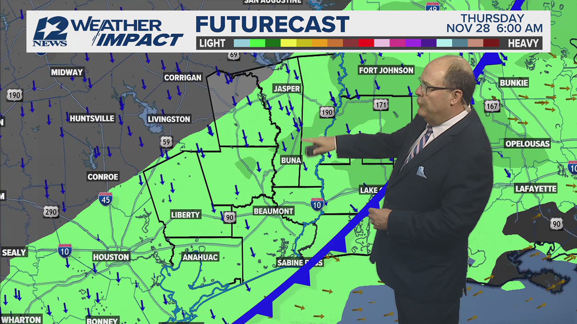

BEAUMONT, Texas — Southeast Texas is getting a break from the heavy rain with scattered showers over the week that could last throughout the weekend.
By Saturday, the activity begins to decrease leaving more respectable rain chances in the forecast.
On Sunday through the first-half of next week, we finally dry out with warm, humid conditions.
MORE | Scroll down for live blog updates
Here's is a list of information and resources for Southeast Texans following a Flash Flood Watch in effect until Saturday morning. This list is not exhaustive.
May 22, 1 p.m. -- Hardin County Judge Wayne McDaniel cancels voluntary evacuation of low-lying areas as of 10 a.m. Saturday.
Residents and businesses near rivers, bayous creeks and other waterways should continue monitoring rising water levels over the next few days, McDaniel said in a Saturday morning news release.
May 21, 4 p.m. -- 409Rescue dispatched to Mauriceville to help evacuate residents in the area.
May 20, 9:15 a.m. -- The Texas Travel Information Center at the state line on Interstate 10 in Orange has been closed due to high water from the Sabine River according to TxDOT Beaumont.
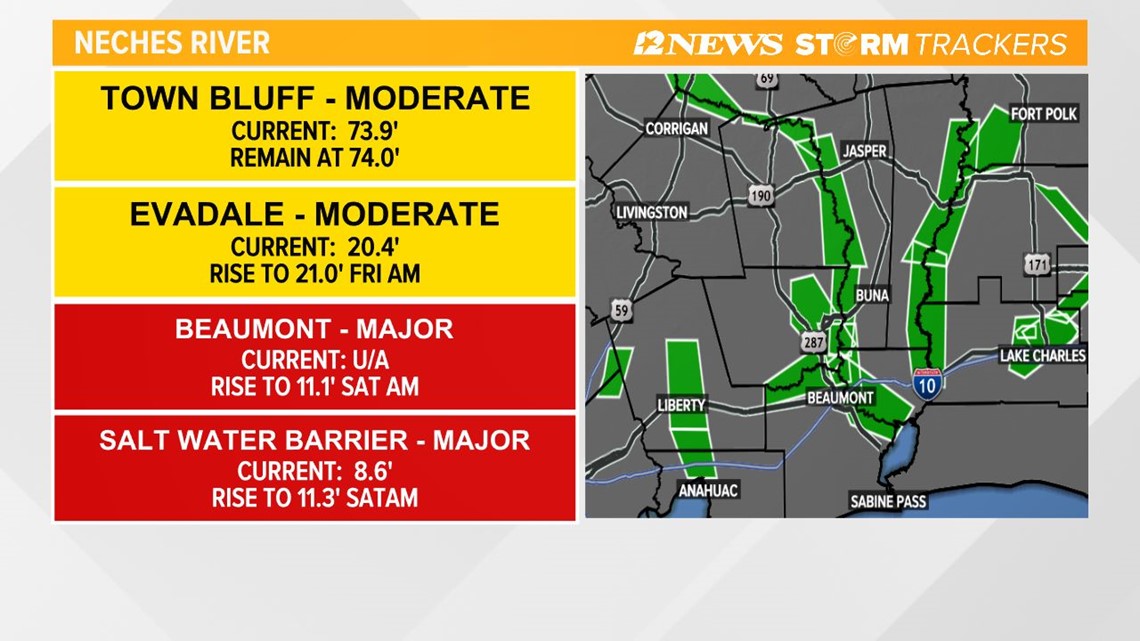
May 20, 7:30 a.m. -- Here's a look at river levels around Southeast Texas...
- NECHES RIVER
- Town Bluff - Moderate
- Current: 73.9', Falling
- Evadale - Moderate
- Current: 20.4', Rising to 26.7' Friday a.m.
- Beaumont - Major
- Current: Unavailable, Rising to 11.1' Saturday a.m.
- Salt Water Barrier - Major
- Current: 8.6', Rising to 11.3' Saturday a.m.
- Town Bluff - Moderate
- SABINE RIVER
- Bon Wier - Moderate
- Current: 34', Rising to 34.8 Friday p.m.
- Deweyville - Moderate
- Current: 27.3', forecast to remain at 27'
- Bon Wier - Moderate
- VILLAGE CREEK
- Near Kountze - Minor
- Current: 18.8', Rising to 22.3' Saturday p.m.
- Near Kountze - Minor
- PINE ISLAND BAYOU
- Sour Lake - Minor
- Current: 28.5', Rising to 28.9' Saturday a.m.
- Sour Lake - Minor
- COW CREEK
- Mauriceville - Moderate
- Current: Moderate flooding, Rising to 20 - 21'
- Mauriceville - Moderate

------------------------------------------------------------------------------
Wednesday Updates
May 19, 12:30 p.m. -- Jasper ISD has announced that on-campus classes are set to start at normal times on Thursday.
May 19, 10:30 a.m. -- More than 2,300 Entergy customers in Southeast Texas remain without power Wednesday morning according to Entergy's online outage map. That's down from 6,400 almost three hours ago. This includes the following counties...
- Hardin County -- 623
- Jefferson County -- 1,880
- Liberty County -- 98
- Orange County -- 262
- Tyler County -- 67
May 19, 8:25 a.m. -- Here's a look at river levels around Southeast Texas...
- NECHES RIVER
- Town Bluff - Moderate
- Current: 76', Falling
- Evadale - Moderate
- Current: 18.8', Rising to 26.7' Friday a.m.
- Beaumont - Major
- Current: 3.5', Rising to 10.9' Sunday a.m.
- Salt Water Barrier - Major
- Current: 6.94', Rising to 11.4' Sunday a.m.
- Town Bluff - Moderate
- SABINE RIVER
- Bon Wier - Moderate
- Current: 34', Rising to 34.8 Friday a.m.
- Deweyville - Moderate
- Current: 26.9', forecast to remain at 27'
- Bon Wier - Moderate
- VILLAGE CREEK
- Near Kountze - Minor
- Current: 19', Rising to 20.7' Friday a.m.
- Near Kountze - Minor
- PINE ISLAND BAYOU
- Sour Lake - Minor
- Current: 27.1', Rising to 28.8' Sunday a.m.
- Sour Lake - Minor
- COW CREEK
- Mauriceville - Moderate
- Current: Moderate flooding, Rising to 18 - 19'
- Mauriceville - Moderate
May 19, 7:45 a.m. -- More than 6,400 Entergy customers in Southeast Texas are without power Wednesday morning according to Entergy's online outage map. This includes the following counties...
- Hardin County -- 1,057
- Jefferson County -- 3,369
- Liberty County -- 94
- Orange County -- 1,917
May 19, 6:55 a.m. -- Many Southeast Texas schools are either meeting virtually today or starting classes late while a few are getting back to normal. Here's the school info we've collected so far.
May 19, 1:15 a.m. -- 12News StormTracker radar shows the leading edge of the line moving across the border into Southwest Louisiana.
Track the rain across Southeast Texas...
----------------------------------------------------------------------------------------------
TUESDAY UPDATES
May 18, 2:50 p.m. -- Orange County officials are recommending a voluntary evacuation for Lake View area, including Four Oaks Ranch Road, Loving Acres, Connelly Road and all other low-lying areas on the Neches River in Orange County.
May 18, 2:30 p.m. -- Newton County officials issue voluntary evacuation order for all low-lying areas of the Sabine River corridor starting at 6 p.m. Tuesday until further notice. The order was issued after reports of unsafe weather conditions expected to cause flood damage countywide, according to a news release.
May 18, 2 p.m. -- Jefferson County Judge Jeff Branick issues disaster declaration for Jefferson County.
May 18, 10:30 a.m. -- Tyler County Judge Jacques Blanchette has declared the county a disaster area.
May 18, 9:50 a.m. -- Residents with flood damage should report their damage to the State of Texas by filling out the Individual State of Texas Assessment Tool (iSTAT) Damage Survey.
May 18, 9:35 a.m. -- Hardin County Judge Wayne McDaniel is warning county residents in low-lying areas to prepare for more potential flooding saying "there is a lot of water headed our way and the time to prepare is now." He noted the high flow release from B.A. Steinhagen Lake and an anticipated release from Lake Sam Rayburn.
May 18, 8:15 a.m. -- In Jasper County sandbags are available at the county barn on FM 1004 and at the Evadale Fire Station. Both locations are self-serve.
May 18, 7:15 a.m. -- Several Southeast Texas school districts are starting classes late or moving to remote learning Tuesday as the threat of more rain continues. Here's a list of the ones we know about.
---------------------------------------------------------------------------------------------------
Monday Updates
May 17, 7 p.m. -- Tyler County Emergency Management and the Tyler County Judge are recommending a voluntary evacuation of Barlow Lake Estates, Sheffield Ferry, and Mount Neches and any other areas that areas that are low lying prone to flooding.
May 17, 5:50 p.m. -- Jefferson County Sheriff's deputies are responding to calls regarding flooding along Interstate 10 and Highway 365 near Gator Country. They are asking for drivers to stay off the roadways unless there is an emergency.
May 17, 5:40 p.m. -- The Jefferson County Sheriff’s Office is asking for drivers to stay off the roadways until water recedes due to the number of stranded drivers and wrecks reported across the county. Deputies are continuing search and rescue missions as wet weather conditions continue.
May 17, 5:30 p.m. -- Traffic is backed up along Highway 365 between Hillebrandt Bayou and Rodair Gully in Jefferson County. Deputies say traffic will resume shortly as they are helping move cattle to higher ground.
May 17, 4:15 p.m. -- Kountze announces the district will be remote for Tuesday, May 18 and will update students as staff of further plans via social media or by phone. The district says students should have their assignments from their teachers.
May 17, 4 p.m. -- Silsbee ISD announces early release of students from school. The district says school will have a two hour late start on Tuesday, May 18. School will begin at 9:45 a.m.
"We encourage all students to eat breakfast prior to school attendance, however, in the event a student is unable to eat, a cold breakfast (i.e., cereal) will be available," the district said in a release.
May 17, 3:15 p.m. -- Sandbags available at all Newton County precinct barns.
- Precinct 1, County Barn
Intersection 2460 & 87 - Precinct 2, County Barn
Highway 1414, Behind Church of God - Precinct 3, County Barn
125 CR 2101
Burkeville, Texas 75932 - Precinct 4, County Barn
42520 Hwy 87
Orange, TX 77632
May 17, 3 p.m. -- Sandbags are available at all Jasper County Precinct barns
- Seth Martindale PCT. 1
146 Co Rd 80
Jasper, Texas 75951 - Roy Parker PCT. 2
1768 FM 777
Jasper, Texas 75951 - Willie Stark PCT. 3
191 Co Rd 411
Kirbyville, Texas 75956 - Vance Moss PCT. 4
15205 HWY 1004 W
Buna, Texas 77612
May 17, 2:30 p.m. -- Sandbags are available in Hardin County. Those in need are encouraged to bring a shovel and to be prepared to fill your own sandbag.
- Hardin County Road & Bridge Departments and Fire Stations: R&B 1 - 1290 Hwy 327 West, Silsbee (409) 385-5501
- R&B 2 - 1315 North Pine Street, Kountze (409) 246-3972
- R&B 3 - 13745 FM 787, Saratoga (936) 274-5411
- R&B 4 - 100 Southland Drive, Lumberton (409) 755-4584
- ESD 2 - (Lumberton Fire Station #2) 8890 Keith Road, Lumberton ESD 5 - (Pinewood Fire Station) 333 Commercial Dr, Sour Lake