
ST. PETERSBURG, Fla. — Hurricane Debby is lashing Florida's West Coast with torrential rainfall, high winds and storm surge as it moves northward in the Gulf.
Far-outer rainbands have spread across the state as the center of the storm entered the southeastern Gulf of Mexico. Weather conditions are expected to worsen throughout Monday morning.
10 Tampa Bay is keeping you ahead of the storm: Download our free mobile app for real-time storm information and breaking alerts, and download 10 Tampa Bay+ on your favorite streaming device for live updates.
See below for a timeline of events this weekend:
Monday
6:03 a.m.: Tornado watch issued for Manatee, Hernando, Polk, Hillsborough, Pinellas, Sarasota, Pasco and Citrus County until 4 p.m.
A tornado warning was issued for Polk County until 6:30 a.m.
5:30 a.m.: The Madiera Beach Recreation Center closed camp for Monday for storm cleanup.
5:15 a.m.: Northbound Howard Frankland is shut down.
A tornado warning has been issued for Manatee, Polk and Hillsborough counties until 5:45 a.m.
5:10 a.m.: Hillsborough County Fire Rescue are responding to an incident where an 18-wheeler lost control and went into the Tampa Bypass Canal overnight. Rescue crews are working to gain access to the cab that's submerged in the water.


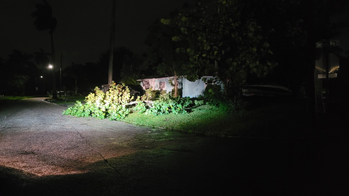
Bradenton Police reported minor damage overnight such as downed trees and limbs and localized flooding near the Manatee River and Wares Creek.

4:55 a.m.: A tornado warning has been issued for Manatee, Polk and Hillsborough counties until 5:15 a.m.
Sunday
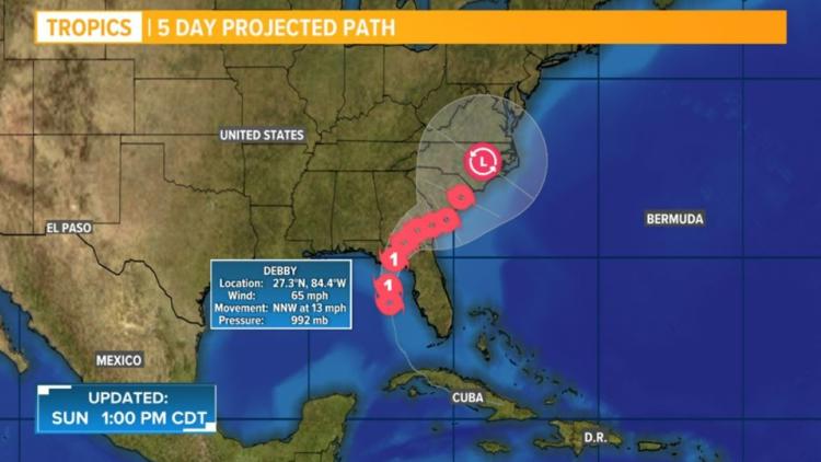
11 p.m.: Debby has strengthened into a Category 1 hurricane as it continues moving north along Florida's west coast.
10 p.m.: Florida Highway Patrol troopers closed the Sunshine Skyway Bridge due to high winds and inclement weather.
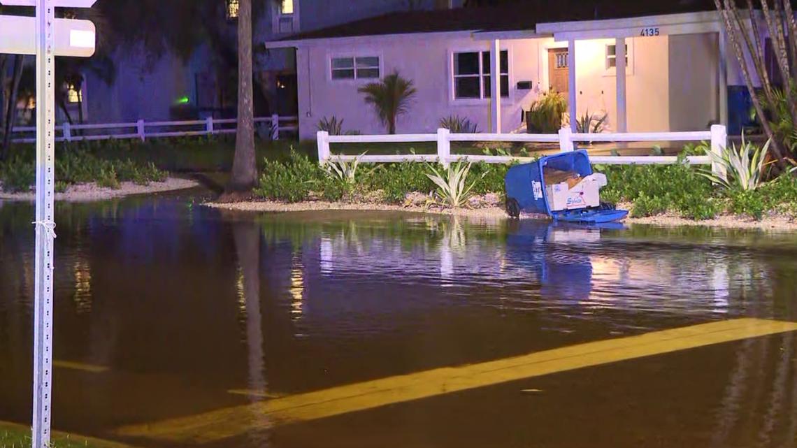
9:55 p.m.: Clearwater Police shared video of a flooded parking lot at the Standard Apartments on Drew Street.
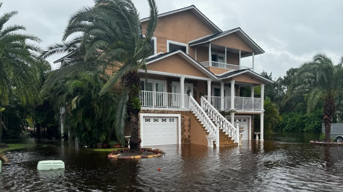
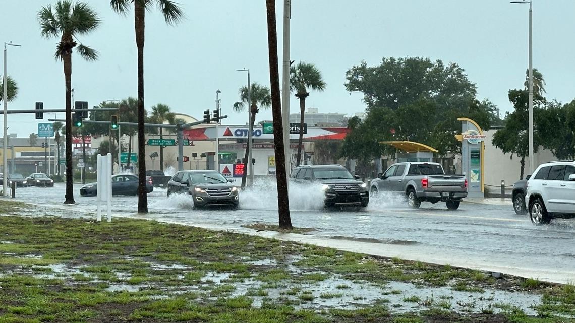
9 p.m.: Several inches of water are seen on roadways in the flood-prone neighborhood of Shore Acres.

8:16 p.m.: Clearwater police responded to State Road 590 near Lori Drive due to a downed tree in the roadway.
7:47 p.m.: The city of North Port will resume trash and recycling pickup on Monday.
7:38 p.m.: Another tornado warning was issued until 8:15 p.m. for parts of Manatee and Sarasota counties.
6:52 p.m.: Tampa offices and services will be open Monday, Aug. 5, including trash, recycling and yard waste collections. People are advised not to place sandbags in city-issued solid waste containers — they can be taken to the city of Tampa McKay Bay Scale House, located at 114 South 34th Street.
City parks are expected to open, however, some parks and services may be impacted depending on any damage.
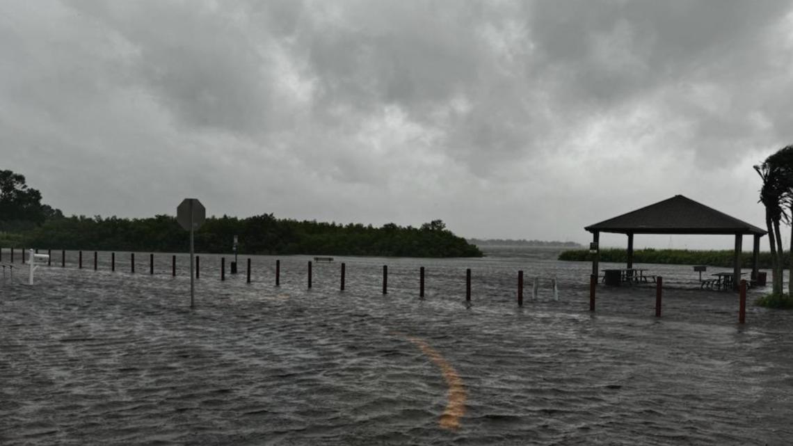
6:43 p.m.: Significant storm surge flooding is seen at Veterans Memorial Park in Oldsmar. A photo shows water flowing across the street and overwhelming the area.
A storm surge of 3-5 feet remains forecast for the immediate Tampa Bay region, including Tampa Bay itself.


6:30 p.m.: More street flooding is being reported in parts of St. Petersburg, including the following locations:
- Shore Acres Blvd. NE/ Arkansas Ave. NE
- Beach Drive/ 5th Ave. NE
6:16 p.m.: Pinellas County parks and officers will reopen at 10 a.m. Monday.
6:10 p.m.: St. Petersburg police are giving an update on street flooding, including the following locations:
- 87th Ave. N and 4th St N
- 78th Av NE and Macoma Drive NE
6:07 p.m.: The Sarasota County government issued a local state of emergency.
6 p.m.: Hillsborough County officers, parks and public amenities will reopen on Monday, Aug. 5. Trash, recycling and yard waste collection will also resume.
5:46 p.m.: A tornado warning was issued until 6:15 p.m. for parts of Pinellas County, including St. Petersburg.
5 p.m.: A tornado warning was issued until 5:30 p.m. for parts of Sarasota and Manatee counties.
4:55 p.m.: A flash flood warning is in effect until 8 p.m. for parts of Sarasota and Manatee counties.
4:03 p.m.: St. Petersburg city officials are warning people not to drive on streets with standing water, including the following that are experiencing flooding:
- 4th Street northbound and southbound from 42th Ave. S. to 45th Ave. S.
- Sunrise Drive S.
- 36th Ave NE to 34th Av NE in the Crisp Park area
- Brightwaters Blvd. NE from Snell isle Blvd to Lamar Way NE
- Shore Acres Blvd NE from Overlook Drive NE to Delaware Ave. NE
- Venetian Blvd NE from Bayou Grande Blvd. NE to Ohio Ave. NE
- Connecticut Ave. NE and Delaware Ave. NE from Shore Acres Blvd. NE to Overlook Drive NE
- 89th Ave. NE to 92th Ave. NE from 1 St. NE to Oak St NE
3:45 p.m.: Gov. Ron DeSantis holds a press conference with other Florida officials in Tallahassee advising residents to have their plans ready and to stay inside. He talked about the flood control barriers that will be around utility stations. Thousands of additional support from the Florida National Guard will help relief operations, and the State Guard is also ready to help.
DeSantis said 17,000 lineworkers will help restore power after the storm. Tarps, generators, sandbags, water bottles and ready-to-eat meals are also in the areas that will be affected.
2:30 p.m.: A flood watch and warning has been issued for five areas of Hillsborough County.
Flood watch:
- Hillsborough River near Morris Bridge Road
- Hillsborough River near Zephyrhills
- Alafia River near Lithia Pinecrest Road
Flood warning:
- Alafia River near U.S. 301
- Little Manatee River near Wimauma
The docks at Indian Mound Park are underwater in Sarasota County.
1:40 p.m.: A tornado warning is in effect for Polk and Hardee counties until 2 p.m.
The Tampa Police Department is closing Bayshore Boulevard from Platt Street to Bay to Bay Boulevard along with numerous side streets due to flooding.
North Casey Key Road in Sarasota County is closed due to flooding and damage.
1:35 p.m.: There is flooding in the Sponge Docks area of Tarpon Springs

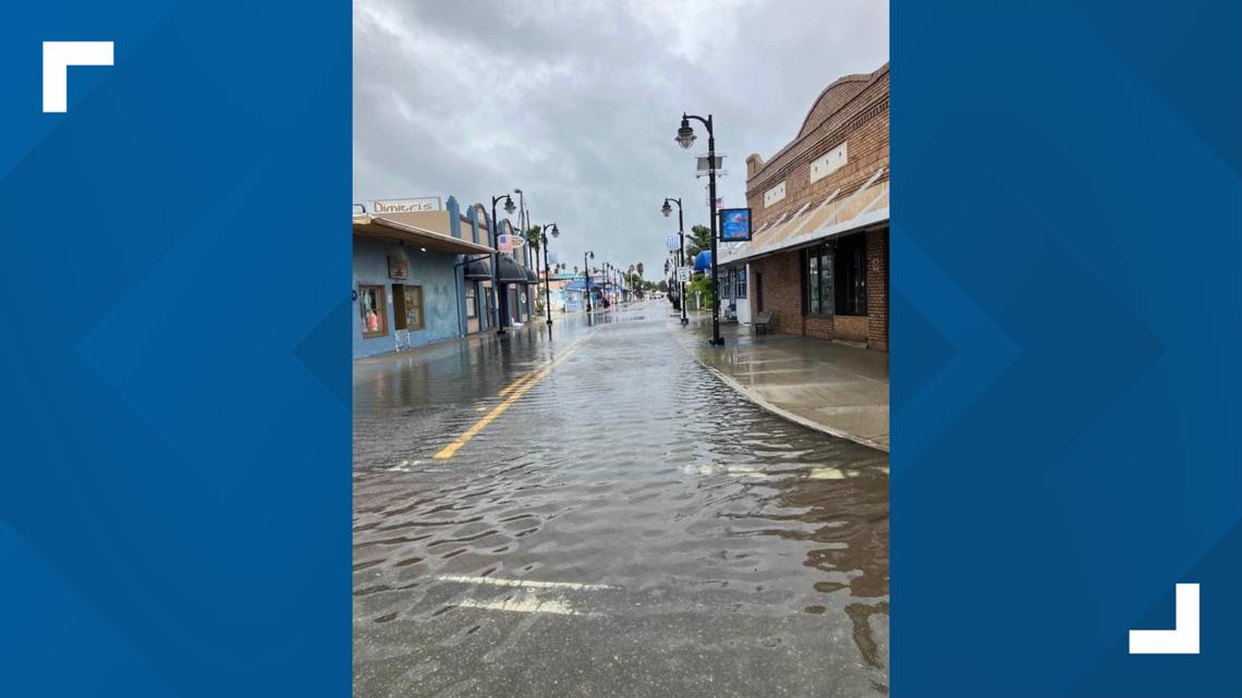
Treasure Island's Sunset Beach is experiencing flooding and high surf.
Gulf Boulevard is also experiencing flooding in some areas.
1:25 p.m.: Citrus County School offices including all schools will be closed on Monday.
Sarasota County officials said the road leading into Caspersen Beach is closed due to erosion.
All SunRunner stations along Gulf Boulevard are closed due to flooding. Those stations include Sun Island Drive, Boca Ciega Drive, 55th Avenue and Beach Access, according to an X post. All other PSTA services are operating as scheduled.
1 p.m.: A tornado warning is in effect until 1:30 p.m. in DeSoto and Hardee counties.
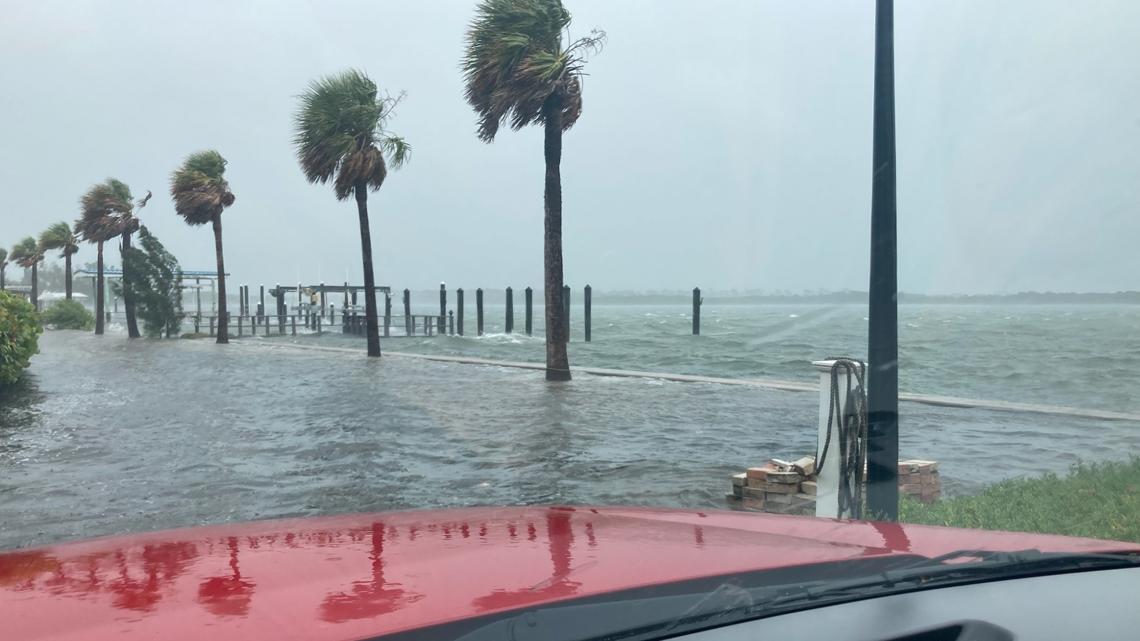
12:55 p.m.: Parts of Pinellas County including Clearwater and the barrier islands are experiencing flooding, according to pictures from Pinellas County Emergency Management.


12:22 p.m.: Harbor Drive at South Brohard in Venice is closed due to "significant erosion," according to an X post. Pictures show the South Jetty walkway submerged in water with waves crashing onto it.
North Beach Road on Siesta Key is also covered with about a foot of sand, Sarasota County Government said in an X post. Officials urged residents to stay off the roads and said the public works crews reported that most roadways are underwater throughout Siesta Key.
12:05 p.m.: Sarasota police urge people to stay put and avoid the area of Benjamin Franklin Drive near the Sandcastle Resort at Lido Beach due to flooding.
12:01 p.m: Delays and cancelations at Tampa International Airport continue to stack up with 115 cancellations and 152 delays. Airport officials said in an X post that the airport is "open and operational." The airport encourages flyers to check with their airline for the latest flight information.
11:16 a.m.: A tornado warning is in effect until 11:45 a.m. for parts of Hardee, Hillsborough, Manatee and Polk counties.
10:55 a.m.: A tornado watch is in effect for all of Florida's west coast, including the Tampa Bay area, because of the potential for quick spin-ups from Tropical Storm Debby.
According to the Storm Prediction Center, the region should prepare for the chance of a few tornadoes and isolated damaging wind gusts to 70 mph.
10:45 a.m.: A tornado warning is in effect until 11:15 a.m. for parts of DeSoto, Hardee and Manatee counties.
10:20 a.m.: A tornado warning has been issued until 10:45 a.m. for Hardee and DeSoto counties.
9:40 a.m.: Busch Gardens Tampa Bay is closed today due to the storm. The park will reopen Monday at 10 a.m.
9:18 a.m.: President Joe Biden approved Florida's Emergency Declaration and ordered federal help to assist with response efforts. FEMA will coordinate disaster relief efforts, and there will be reimbursement for mass care including evacuation and shelter support for many counties including Hernando, Hillsborough, Pinellas, Sarasota, Manatee, Pasco and Citrus.
9 a.m.: As of this writing, there are 31 cancellations and 111 delays at Tampa International Airport. Travelers will want to check with their airline for their latest flight information.
8 a.m.: Tropical Storm Debby is forecast to rapidly strength before landfall in Florida's Big Bend region, according to the National Weather Service. It is located about 115 miles southwest of Tampa.
7:30 a.m.: Florida Gov. Ron DeSantis held a news conference with state officials warning of heavy rain. DeSantis cautioned that flooding and power outages are possible and encouraged residents to have their storm plan ready and be prepared. He warned people to not go into flood water or go outside because high winds can cause debris to fly around. DeSantis described the state's efforts to construct flood control devices at utility stations ahead of the storm to prevent outages.
Saturday
11 p.m.: Tropical Storm Debby is about 260 miles south-southwest of Tampa. It's expected to move across the eastern Gulf of Mexico through Sunday night. See the latest track.
9 p.m.: Gov. Ron DeSantis announces a news conference on Tropical Storm Debby at 7:30 a.m. Sunday in Tallahassee.
8 p.m.: Air Force and NOAA Hurricane Hunters are en route to investigate Tropical Storm Debby in the Gulf of Mexico.
5:23 p.m.: All Pinellas County parks and preserves are set to close on Sunday. Boat ramps will also be closed except for those taking boats out of the water for safety.
5 p.m.: Tropical Storm Debby forms in the Gulf of Mexico. Forecasters now expect Debby to reach Category 1 hurricane strength as it reaches the Big Bend region of Florida. See the latest track.
4:09 p.m.: Gov. Ron DeSantis shares steps the Florida Department of Emergency Services is taking to prepare for storm impacts, including activating the Florida National Guard and readying high-water vehicles, airboats and shallow draft boats. The state has also equipped response teams with 170 pallets of water, 30 pallets of shelf-stable meals, seven pallets of tarps and 3,000 sandbags.
3:43 p.m.: Hillsborough County parks, conservation parks, preserves and trails will be closed Sunday. This includes boat ramps and dog parks.
2 p.m.: The center of Tropical Depression Four emerged over the southeastern Gulf of Mexico after being over Cuba. The 35-mph storm is expected to become Tropical Storm Debby later in the day.
1:03 p.m.: Tampa International Airport is planning to stay open and operational throughout the weekend, officials said. However, bad weather will likely prompt numerous cancellations and delays. People are encouraged to check with their airline for flight updates.
10:14 a.m.: The city of Tampa activates its call center ahead of the storm. Until 7 p.m., people can call 833-TPA-INFO to speak with a city staff member. The call center will be open from 9 a.m to 7 p.m. Sunday.