
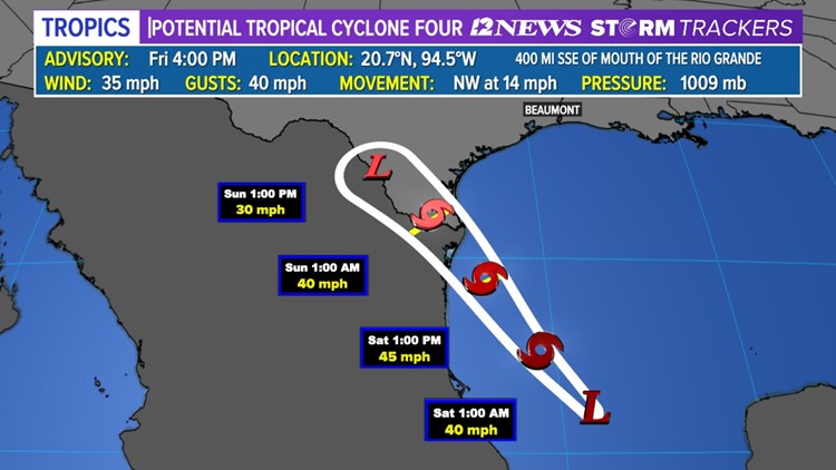
BEAUMONT, Texas — A new tropical wave, called Potential Tropical Cyclone Four, is drawing interest in the southern Gulf of Mexico, more precisely the Bay of Campeche, west and south of the Yucatan Peninsula in Mexico.
It's forecasted to continue moving northwest and become Danielle Friday night. Danielle will make landfall late Saturday in northeast Mexico/South Texas.
As for impacts to southeast Texas, direct impacts are not expected. Moist, tropical air will be pushed in our direction and that moist air interacting with our lingering boundary offshore will act to enhance our rain chances later in the weekend and a good chunk of next week.
What is a Potential Tropical Cyclone?
The National Hurricane Center said a Potential Tropical Cyclone is a term used in National Weather Service advisory products to describe a disturbance that is not yet a tropical cyclone, but which poses the threat of bringing tropical storm or hurricane conditions to land areas within 48 hours.
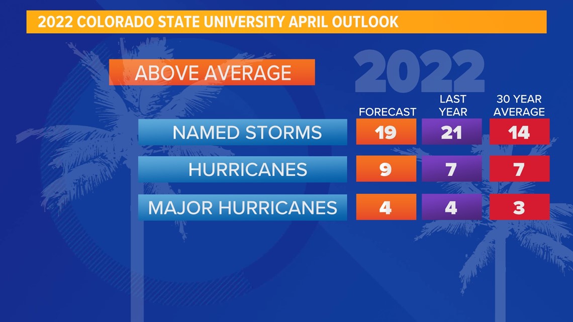
2022 Hurricane Season Outlook
The 2022 Hurricane season is expected to be more active than normal with a projected 19 named storms—9 of which are forecasted to be hurricanes, 4 of them major hurricanes (Cat 3+).
On average we see around 14 named storms each season -- 7 of which are hurricanes, 3 of them major hurricanes.
According to the outlook from the Colorado State University Tropical Meteorology Project this is the case because of a couple different factors, namely the absence of an El Niño.

We are currently under a La Niña phase. As of now, it hasn’t had much impact on the eastern and central tropical Atlantic sea surface temperatures, which remain near average. However, we are expecting to have a weak La Niña or a neutral phase remain in place, which would favor warming.
In addition to that, the Caribbean and subtropical Atlantic sea surface temperatures are running warmer than normal too. Wind shear is still expected to be lower than normal and for that season, development and livelihood of hurricanes this season is expected to be more favorable. Warm water is the fuel and weak wind protects the hurricanes from ripping apart too quickly.
Last year, we had 21 named storms, 7 of which were hurricanes and 4 that were major (Cat 3+). This season is expected to be fairly similar. Hurricane season starts June 1st and ends November 30th.
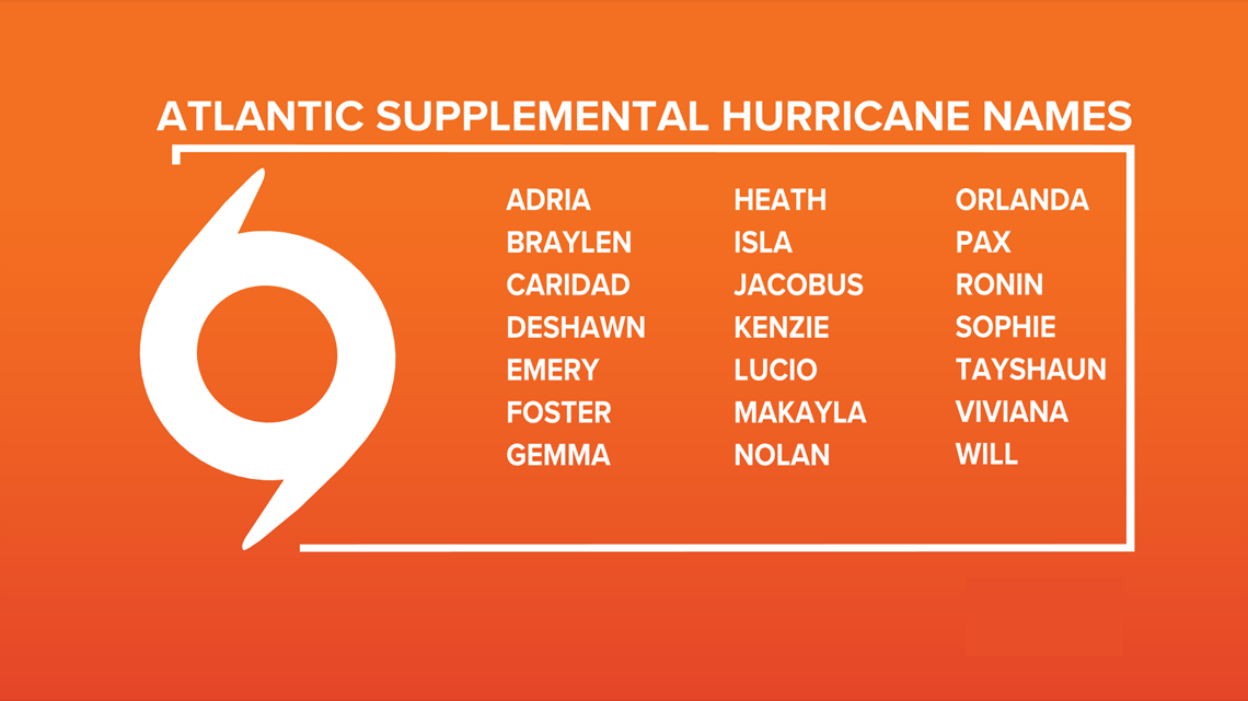
The World Meteorological Organization announced in 2021 the Greek alphabet will not be used in the future because it "creates a distraction from the communication of hazard and storm warnings and is potentially confusing."

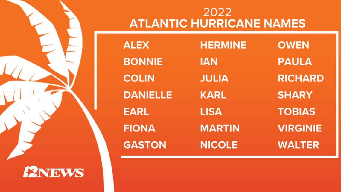
There has been only one other season that used the extra set of names, and that was in 2005. The World Meteorological Organization released a new set of supplemental names that will be used if the season exhausts the standard list.

GET NEWS & WEATHER ALERTS | Download the 12News App to your mobile device
Also on 12NewsNow.com...