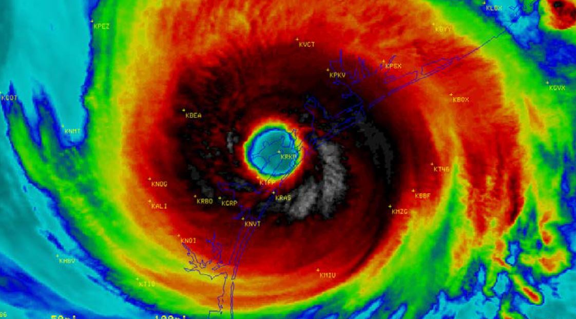
HOUSTON – The National Hurricane Center released Thursday its official 76-page report on Hurricane Harvey and its impacts on Texas and the rest of the United States.
According to the NHC, Harvey’s rains caused catastrophic flooding, making it the second-most costly hurricane in U.S. history, after accounting for inflation, behind only Katrina in 2005.
"The latest NOAA damage estimate from Harvey is $125 billion, with the 90% confidence interval ranging from $90 to $160 billion. The mid-point of the estimate would tie Katrina (2005) as the costliest United States tropical cyclone, which was also $125 billion."
“At least 68 people died from the direct effects of the storm in Texas, the largest number of direct deaths from a tropical cyclone in that state since 1919,” the report stated.
In Southeast Texas there were 19 deaths attricbuted to the storm and its aftermath with five in Jefferson County, nine in Orange County, one in Hardin County and two each in Newton and Jasper County.
In August 2017, Harvey rapidly intensified into a category 4 hurricane before making landfall along the middle Texas coast. The storm stalled, with its center over or near the Texas coast for four days, “dropping historic amounts of rainfall of more than 60 inches over southeastern Texas.”
“Harvey was the most significant tropical cyclone rainfall event in United States history, both in scope and peak rainfall amounts, since reliable rainfall records began around the 1880s. The highest storm total rainfall report from Harvey was 60.58 inches near Nederland, Texas, with another report of 60.54 inches from near Groves, Texas.”
At least 160,000 structures were flooded in Harris and Galveston counties, according to the NHC report.
Outside of the Houston area, serious flood damage was reported farther east in Jefferson, Orange, Hardin and Tyler counties, with about 110,000 structures flooded.
Other notes from the NHC report:
In Southeast Texas... "Beyond the Houston metro area, the most serious flood damage was noted farther east in Texas over Jefferson, Orange, Hardin and Tyler counties, with about 110,000 structures (about one-third of the total structures damaged by Harvey) in those counties flooded.
Flooding induced by widespread rainfall amounts of 40 inches resulted in several oil and gas refineries in the Golden Triangle area (southeastern Texas between Beaumont, Port Arthur and Orange) going offline for days, and consequently gas prices in the United States spiked to their highest levels in two years.
Record water levels were seen on Pine Island Bayou, the Lower Neches River and Cow Bayou.
A bridge collapse occurred at the Highway 96 Bridge over Village Creek near Silsbee, and flood
waters inundated parts of I-10 in Rose City, Vidor and near the city of Orange.
Historic flooding was also reported in many cities across these counties, including Port Arthur, Lumberton, Warren, Groves, Bevil Oaks, Sour Lake, Hamshire, Fannett, China, Silsbee, Lakeview, Mauriceville and northeastern Beaumont."
In Jefferson County... "The heaviest rain shifted eastward into Jefferson County on 28-30 August, which was located in the deformation zone and near the stationary front (Fig. 15), leading to the absolute rainfall maxima in that area.
Harvey also produced heavy rain over Louisiana, with a peak amount of 23.71 inches recorded west of Vinton.
Radar data, however, suggests an estimate of about 40 inches for a maximum value, which is considered more representative of peak rainfall in that state since there were few observations over extreme southwestern Louisiana"
Major-to-record flooding occurred in Liberty County along the Trinity River with numerous roads inundated including FM 787. Many homes and subdivisions were either cut off or inundated, specifically north of the city of Liberty and in the Grenada Lakes Estates subdivision. Significant damage occurred along the banks of the river due to high flows and several utility lines were severed due to the loss of poles in the vicinity of the Romayor gauge. Record river levels were also observed on the east fork of the San Jacinto River causing significant flooding in Cleveland, Williams and Plum Grove. High flows caused significant scouring of the state 105 (business) road; other roads were washed out as well, with bridge washouts or closures observed in many parts of the county. At least 1,000 homes were damaged in the county.
In Chambers County, record floods over the lowlands occurred along the Trinity River. Cedar Bayou was out of its banks in many locations, with significant flooding observed in Baytown. Numerous roads and homes were inundated across the county, including extensive flooding in the Milam Bend subdivision. High flows from the Trinity River impacted the navigation community for several weeks. An estimated 3,000 homes were damaged, and numerous businesses had significant damage.”
“In Fort Bend County, major flooding occurred with both the Brazos and San Bernard Rivers experiencing record floods. Major-to-record flooding occurred along the Brazos River from Richmond to Rosharon. Significant home flooding occurred in areas of Simonton, Richmond, Rosenburg, and Thompsons. Nearly 200,000 people were evacuated due to levee concerns and restrictions. Major-to-record flooding also occurred on the San Bernard River at both East Bernard and Boling, with the hardest hit area being Tierra Grande. At least 8,500 homes in this county were damaged by Harvey.
In Brazoria County, the Brazos and San Bernard Rivers experienced record water levels, which caused widespread floods across the county. The hardest hit communities were in Baileys Prairie, Richard and West Columbia. Widespread major flooding on the Brazos River and Oyster Creek led to numerous roads and homes flooding in Columbia Lakes, Mallard Lakes, Great Lakes, Riverside Estates and the Bar X Ranch subdivisions, as well as homes on CR 39. Flooding damaged the bridge over Cow Creek at CR 25, making it impassable. Major flooding also occurred along the San Bernard River at Sweeny with widespread inundation of the west floodplain. The Phillips 66 refinery took on water near Little Linville Bayou. Hanson Riverside Park was inundated, and water overtopped the Phillips Terminal, halting all vessel traffic. High flows from the Brazos and San Bernard Rivers caused navigation problems for several weeks. Over 9,000 homes experienced flood damage from the storm.
In Wharton County, widespread catastrophic flooding occurred from both the Colorado and San Bernard Rivers, causing Highway 59 to close between Hungerford and El Campo. The flooding inundated areas of Wharton, with hundreds of homes and businesses under water in many communities including Hobben Oaks, Bear Bottom, Elm Grove, River Valley and Pecan Valley. Other areas such as Glenflora, Peach Acres and the Orchard were hard hit. Major-to-record flooding also occurred on the San Bernard River at both East Bernard and Boling, with the hardest hits areas being El Lobo and New Gulf. Major lowland flooding occurred with many homes (including some on the second-story) and businesses being inundated, and the cotton crop was decimated. An estimated 2,000 homes were damaged or destroyed in the county.
Major lowland flooding occurred in Matagorda County along the Tres Palacios River. Many roadways were under water, and homes in the El Dorado Country, Oak Grove, and Tres Palacios Oaks subdivisions flooded. Major flooding also occurred on the Colorado River at Bay City as levees were overtopped by 2 ft of water. High flows from the Colorado and Tres Palacios Rivers impacted river navigation for several weeks. Roughly 2,900 homes were damaged in the county.
In San Jacinto County, major lowland flooding occurred on the Trinity River near Goodrich with damage and debris noted near the boat ramp and channel in proximity to the river gauge. Major flooding occurred upstream near Lake Livingston, with roads and many homes south of the lake being inundated. About 3,300 homes were damaged in the county.
You can read the full report and NHC data here (PDF): https://www.nhc.noaa.gov/data/tcr/AL092017_Harvey.pdf


